A Ten-Minute Walk for Noticing Street Corners
A ten-minute walk for noticing street corners helps you map how storefronts, entrances, and public spaces meet—and choose a useful detail to follow.
Street corners reveal how a neighborhood’s everyday uses meet: a shop may face one way, a bus stop another, while a side street opens onto a park. A ten-minute walk for noticing street corners can help you read those relationships by tracking what each corner connects, rather than explaining why the streets took their shape.
Track What Meets
At a corner, look beyond the pavement and note the uses gathered around it. Check for storefronts, apartment entrances, civic buildings, vacant lots, bus stops, playground gates, and places where people pause. These details make a corner’s role easier to compare with the next one.
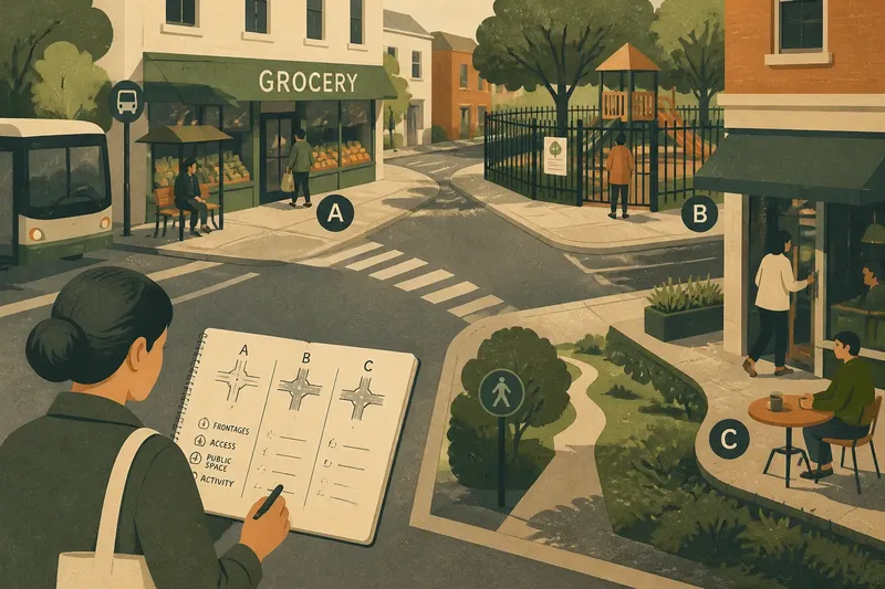
Use four headings in your notes: frontages (what faces the street), access (doors, paths, and transit stops), public space (parks, plazas, or seating), and activity (what people appear to be doing). Write what is visible, not what you assume a place is for.
A storefront with a shutter down is still a storefront; a doorway does not tell you who may enter. Record the feature and leave uncertain details open.
Choose a Short Route
Select three corners within a familiar, walkable area. A route along one commercial street can show how shops give way to homes; a small loop beside a park can show how entrances, paths, and surrounding buildings relate. Choose locations you can view from public sidewalks.
- Frontage: Check whether doors or windows face the corner. If they do, note which street they address; if they do not, record a blank wall or side elevation instead.
- Access: Look for a path, gate, transit stop, or building entrance. If a route visibly connects the corner to another place, note its direction; if access is unclear, describe only the visible opening or barrier.
- Public space: Check for a park edge, bench, plaza, or planted area. If people can reach it from the sidewalk, note the apparent connection; if fencing interrupts it, record the fence and do not assume entry is permitted.
- Activity: Notice whether people are waiting, passing through, sitting, or entering a building. If an activity is visible, describe it briefly; if no one is present, note that instead of deciding the place is unused.
- Corner connection: Check what each of the two streets leads toward in view, such as a market, school, or open space. If a destination is clearly identifiable, name it; if not, use a direction like “toward the main road.”
- Temporary conditions: Check for scaffolding, delivery vehicles, construction fencing, or seasonal foliage. If a feature seems temporary, mark it as a condition of this visit; if it appears fixed, describe its material or placement without assigning it a history.
Use neutral labels such as A, B, and C. That keeps an early impression—“the park corner”—from replacing the details that would make the observation useful later.
Compare Corner Roles
At each stop, sketch a simple cross for the streets and add short labels for the surrounding uses. You do not need a scale drawing. A mark for “bakery,” “bus stop,” or “park gate” can show how several destinations gather around one junction.
Then compare the corners by what they connect. One may link homes to a bus stop, another may bring a park path to a row of shops, and a third may offer no visible entrance at all. Those contrasts describe how the street feels to approach and use without turning a few stops into a claim about the whole neighborhood.
Say you choose three hypothetical corners on a short route. At A, you see a grocery entrance and a bus stop; at B, a fenced playground and a side street; at C, a café door and a marked path into a small green. You write those features under the same headings, then compare the connections: A joins a shop to transit, B places a play space beside the route but behind a fence, and C connects a business frontage to green space. The notes show different visible relationships; they do not establish who uses each place or why it was laid out that way.
Questions About Corners?
What should I record first?
Start with the visible uses and connections: what faces the corner, where an entrance or path leads, and whether public space touches the sidewalk. Add a sketch if the relationship is hard to capture in a sentence.
How do I compare two corners?
Use the same headings for both, then look for differences in frontages, access, public space, and visible activity. If the notes match, record the shared pattern rather than forcing a distinction.
What if a place looks closed?
Describe what you can see, such as a locked gate, lowered shutter, or posted sign. Do not infer operating hours, ownership, or permission to enter from appearance alone.
Can this walk explain a neighborhood’s history?
No short walk can establish why a street or building was created. It can give you a precise list of visible relationships and a better question to pursue with local records or knowledgeable residents.
Follow One Detail
After the walk, choose one feature that connects the corners: repeated shop entrances, paths leading to public space, or transit stops beside residential streets. Mark where it appears and where it does not. That small comparison can point to a useful next question without pretending to answer it.
Keep the record practical: name the place, describe the visible connection, and note any barrier or temporary condition. A ten-minute walk for noticing street corners is most useful when it leaves you with one clear pattern to look for on another route.