The Boundary Line Myth: Why a Neighbourhood Edge Can Be Fuzzy
A neighborhood boundary can shift with purpose and routine. Learn to read overlapping local edges without forcing them into one official line.
Ask three people where Bellwether ends, and you may get three different answers. A shopkeeper points to the railway bridge, a parent names the school catchment, and a bus rider says the last stop before the route turns. The neighborhood boundary is not necessarily one hidden line waiting to be discovered; it can be several useful edges drawn for different reasons.
That distinction matters when you are trying to understand a place, give directions, or decide whether a street belongs to one neighborhood or another. A fuzzy edge is not a failure of local knowledge. It is often evidence that people use the same ground in different ways.
One place, several edges
Neighborhood names make places feel neatly contained, but the boundaries people use are often practical rather than universal. A resident might think in terms of the blocks around home, while a local business may define its area by delivery routes and a school by the addresses it serves.
Those lines can overlap without matching. The park may be the center of one person’s neighborhood, the eastern edge of another’s, and a destination outside both for someone who lives beyond the main road.
Try asking what a boundary is for before asking where it lies. “Where does the school area end?” and “Where do people stop calling this Bellwether?” are different questions, even if they sound like requests for the same map.
Bellwether’s shifting edge
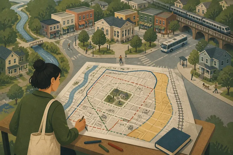
Imagine a clearly hypothetical neighborhood called Bellwether, arranged around a small square, a library, and a row of mixed-use streets. A creek runs along its western side, while a busy avenue and a railway line lie to the east. The name appears on a community noticeboard, but no single sign marks the neighborhood’s full perimeter.
At the square, a resident named Lena is trying to make a simple neighborhood map for a community event. She starts by asking people at the library and nearby shops to describe Bellwether’s edge. Their answers form three overlapping shapes, not one shared outline.
For the business owner, Bellwether extends east to the railway bridge because that is where customers still describe themselves as shopping locally. For a parent, the school’s attendance area crosses the avenue and includes a street many residents call Eastbank. A bus rider uses a third boundary: the point where the route leaves the square and heads toward the next commercial center.
None of these answers is automatically wrong. Each describes a different relationship with the place: commerce, school access, or regular travel. Lena’s first useful discovery is not a line but a set of purposes.
What makes an edge?
Some boundaries follow visible features. A creek, railway cutting, major avenue, or long wall can interrupt movement and make a clear edge for everyday navigation. But a physical barrier does not always settle the name: a bridge may connect two sides, and people who cross it daily may feel attached to both.
Other edges follow services. School zones, library services, delivery areas, and residents’ groups may each use boundaries designed for their own work. Those limits can be documented and specific, yet they should not be mistaken for a complete definition of neighborhood identity.
Routine creates another kind of border. Someone who walks to the same grocery, waits at the same bus stop, and meets friends in the square may experience Bellwether as extending along that route. A person living nearby but facing the other direction may orient toward a different cluster of shops and call the shared street the edge.
Names also travel unevenly. A neighborhood label may be familiar around the square and less common a few blocks away. New housing, a changed business district, or an older local name can make the transition gradual, with residents choosing different terms for the same stretch.
Lena’s map in layers
Rather than force the answers into one border, Lena revises the map. She marks the creek and railway as physical features, then adds separate outlines for the school area, the businesses’ customary service patch, and the routes people mention when describing Bellwether.
She uses different line styles and gives each one a plain-language label. A solid line shows the creek and railway; a dotted one marks the area described by several residents; a shaded band indicates streets where the neighborhood name overlaps with Eastbank. The map now communicates uncertainty without making the place seem unknowable.
For the community event, Lena also changes the wording on the invitation. Instead of saying the event is “inside Bellwether’s boundary,” she says it is at the library near the square, on streets commonly associated with Bellwether. That description is more useful to visitors and more honest about how the name is used.
Say you are making a similar map for a neighborhood walk. You ask a shopkeeper, a transit rider, and a nearby resident the same open question, then note that their edges differ by purpose; the expected result is a map that shows a shared center and an overlap zone rather than a falsely precise perimeter.
Questions about local edges?
How can I tell whether a boundary is official?
Look for the purpose attached to it: a school attendance area, municipal district, or service zone may have a published map and a defined authority. A neighborhood name used in conversation may have no single formal perimeter, so identify the source and purpose before treating a line as official.
Why do residents disagree about where a neighborhood ends?
They may travel in different directions, use different services, or connect the neighborhood name to different landmarks. Their answers can all be accurate accounts of daily life, even when the implied outlines do not match.
Can two neighborhood names cover the same street?
Yes. A street can sit in an overlap where people use one name for its western side and another for its eastern side, or where two names serve different local purposes. Ask how a speaker uses each name rather than assuming the labels must be mutually exclusive.
What should I say when giving directions near an edge?
Use a specific destination and a recognizable nearby feature, such as the library by the square or the stop beside the railway bridge. If the neighborhood label may be disputed, give the street or landmark first and treat the area name as extra context.
Read the overlap
Lena’s finished map does not solve Bellwether by choosing a winner. It separates the questions people had blended together: where a physical barrier sits, which area a service covers, and where residents use a familiar name. That makes the map easier to revise when a route, institution, or local habit changes.
The same approach works when comparing neighborhoods. Ask who uses a boundary, what decision it helps them make, and whether the line comes from a physical feature, an institution, or routine. Then watch for streets where the answers overlap; those are often the places where local identity is most actively negotiated.
A neighborhood boundary can be fuzzy without being meaningless. The phrase “near the edge” may describe a genuine local experience, while a layered map can show why that edge shifts from one person’s route to another’s. When you hear a confident boundary claim, ask what it helps that person explain—and let the answer shape the map.