Why Streets Bend: The Clues in a Neighbourhood's Layout
Why streets bend can reveal how terrain and routes shape a neighbourhood. Learn to read a curve without mistaking its visible form for proof of its history.
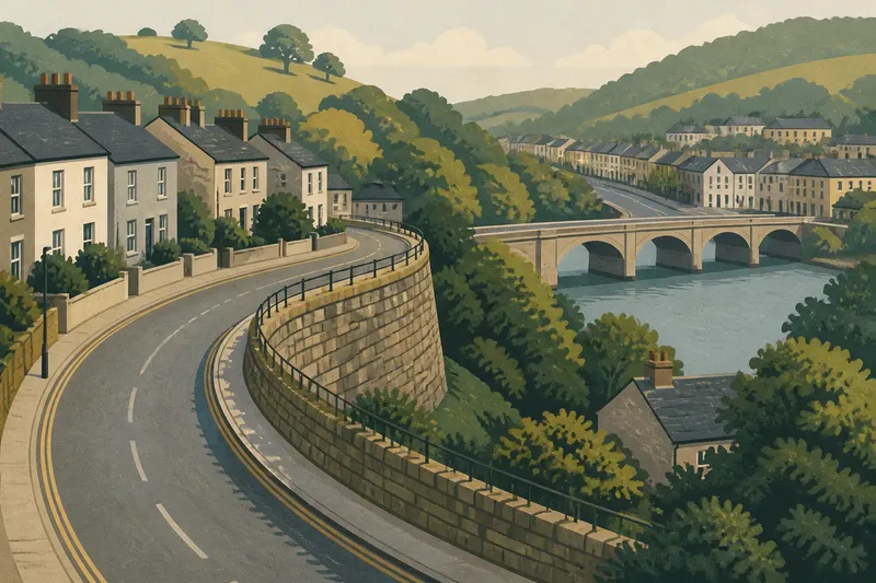
Why streets bend is easiest to answer when you look beyond the curve itself: a road may track a hillside, meet a crossing, or change direction at an old boundary. A street map shows the shape, but it cannot identify the cause on its own. Read the bend as a problem of competing explanations, not as a clue that tells a complete story.
Compare possible causes
Start with a specific curve on a public street map. Before walking it, list a few plausible explanations: terrain, a route connection, a property edge, or a later design choice. Then ask what visible feature each explanation would lead you to expect.
- Terrain: Check whether the street follows a slope or skirts a hollow; if the ground seems to match the curve, keep terrain as a possibility, but note when walls, buildings, or trees block the view.
- Route connection: Look beyond both ends of the bend for a bridge, crossing, or continuous street; if the route points toward one, consider a connection, but do not assume the curve was built for that purpose.
- Boundary: Notice whether the bend tracks a fence line, abrupt change in parcel shape, or edge between different street patterns; if it does, consider a boundary, but leave the cause open unless dependable local records support it.
- Design choice: Compare the curve with nearby streets and intersections; if it appears isolated or regular in a way the surrounding layout does not, consider a planned change, but avoid assigning a date or designer from appearance alone.
- Unclear ground: Check whether pavement, retaining walls, construction, or dense planting hides the land; if so, mark the terrain as unreadable and use route or boundary clues instead.
- Conflicting clues: If the curve could fit more than one explanation, keep each plausible option in play; if no visible feature separates them, report the cause as unresolved rather than choosing the neatest story.
These comparisons are more useful than a day-by-day viewing routine because they make each proposed cause answerable to a particular clue. A curve may fit several patterns at once, and that overlap is part of the reading.
Read the ground
A street that curves along a hillside may avoid a steep climb, while a route near a low area may bend around ground that is difficult to cross. From a safe public viewpoint, compare the street’s direction with the visible rise and fall of the land.
Surface clues can mislead. Retaining walls, building foundations, tree cover, and later grading may hide or alter the original shape, so describe what is visible rather than naming a hill, stream bed, or slope you cannot judge clearly.
Follow the connections
Look at the routes on both sides of the bend. A street may turn toward a bridge, join a path, or connect streets that do not line up with the surrounding grid; these relationships can help explain the curve without establishing when or why it took its present form.
Imagine a map showing a bend aimed toward a nearby bridge, while a retaining wall hides the ground beside the road. The route connection is visible, but the terrain is not: describe the bridge alignment as a clue, set aside the hidden slope as undecidable, and keep any claim about the original reason tentative.
Questions about bends?
Does a curved street always follow a hill?
No. A curve may relate to a route connection, a boundary, or a later design choice. Compare the ground with nearby streets before favoring one explanation.
Can a map explain why a road turns?
A map shows the curve and its connections, but usually cannot reveal the original land conditions or the decision behind the layout. Use it to identify what to examine on the ground.
What if two explanations fit?
Keep both if each matches a visible clue, and state what remains unclear. If the clues do not distinguish them, the cause is unresolved.
Can appearance show that a route is old?
An irregular lane or a route cutting across a street grid may prompt the question, but appearance alone cannot establish age. Describe the alignment and consult reliable local documentation before making a historical claim.
Describe the evidence
When explaining a bend, separate the shape from the proposed cause: “The road curves beside a steep bank” is an observation; “the road was built to avoid the slope” is an interpretation. Add what you cannot see, such as ground hidden by a wall, so readers can judge the limits of the explanation.
For a useful account of why streets bend, state the location of the curve, the visible clue that supports each possibility, and what remains uncertain. A clear description can show how terrain, routes, or boundaries may relate to a street without turning a plausible reading into an established history.